Digital Land Surveyor Courses
Want to become Land Surveyor, Aerial Surveyor or add value to job profile with skills like Total Station Surveying, DGPS Surveying, Drone Surveying then these courses are for you.
3 months
Diploma in Digital Land Surveying
Traditional surveying technologies like plain table, theodolite surveying is replaced by total station and drone surveying technics. Learn complete Land Surveying Workflows includes field procedure of Total Station Survey, DGPS Survey with office procedure on how to process survey data to produce Topographical, L-Section, Cross-Section maps, calculate volumes.
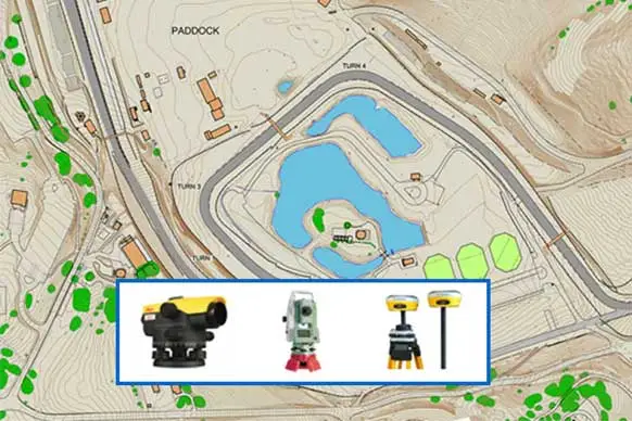
Covers 3 surveying instruments, AutoLevel, Total Station, DGPS/DGNSS. Course is design for whom who want to start Land Surveying Business or secure job in Land Surveyor job.
3 months
Diploma in Drone Surveying and Mapping
Course will take you through GIS concepts and hand-on exercise data transfer, geo-referencing, digitization, GIS analysis. GNSS, DGNSS (GPS, DGPS) concepts with errors and RTK, PPK post processing with hands-on exercise. Aerial surveying fundamental concepts and hands-on exercise on, flight planning and execution, image processing using different photogrammetric software's, point cloud classification, DEM editing, removing noise and much more. Manipulation of data point could data for smooth DEM generation covered in popular surveying software tools.
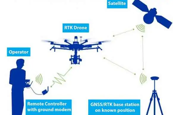
Covers RTK Drone surveying instruments with base station. Drone Surveying & Mapping course best suits for fresher and entrepreneur who want secure job in rapidly developing drone industry or start drone surveying business.
3 months
Master in Land Surveying and Mapping
Course will take you through GIS concepts and hand-on exercise data transfer, geo-referencing, digitization, GIS analysis. GNSS, DGNSS (GPS, DGPS) concepts with errors and RTK, PPK post processing with hands-on exercise. Aerial surveying fundamental concepts and hands-on exercise on, flight planning and execution, image processing using different photogrammetric software's, point cloud classification, DEM editing, removing noise and much more. Manipulation of data point could data for smooth DEM generation covered in popular surveying software tools. Perform hybrid surveying with Total Station, DGPS and RTK Drone. Produce seamless, error free integrated data from hybrid surveying.
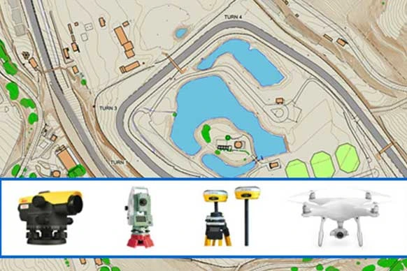
Covers 4 surveying instruments, AutoLevel, Total Station, DGPS/DGNSS, RTK Drone with base station. Mastering in Land Surveying & Mapping course best suits for entrepreneur start drone surveying business.
Compare Land Survey Courses
| 3 months Land Surveyor Course |
3 months Drone Surveyor Course |
3.1 months Master in Land Surveyor & Mappong Course |
|
|---|---|---|---|
| GIS Surveying & Mapping | |||
| AutoCAD | |||
| Surveying CAD | |||
| Auto Level | |||
| Total Station | |||
| DGNSS/DGPS | |||
| RTK Drone | |||
| Drone Data Processing | |||
| LiDAR Data Processing |
Past participants work at:


Participant Profile
What Participant said:
-
Total Station Training
4 Days Offline
-
Civil 3D Course for Surveyors
32 Hours Offline Online
-
Drone Course
2 days Offline
-
Road Design with Civil 3D and Global Mapper
6 days Offline
-
DGPS Training
2 days Offline
-
Drone Surveying Course
5 Days Offline
-
Surveying with Terrestrial Laser Scanning
2 days Offline
-
Drone Data Processing with Agisoft Metashape
24 hours Offline Online
-
AutoCAD Map 3D Course
24 hours Offline Online
-
Global Mapper Training
24 hours Offline Online
-
LiDAR Training
40 hours Offline Online
-
Pix4D Training
24 Hours Offline Online