Drone Surveying Courses
Learn how to use drones for land surveying with our comprehensive courses. Our drone land surveying courses cover a range of topics, including drone technology, aerial photography, photogrammetry, and data processing. You'll learn how to capture high-resolution aerial images and generate accurate 3D models and maps. Our hands-on approach and practical exercises help you develop the necessary skills and experience to use drones for land surveying in a variety of fields, including construction, agriculture, and environmental monitoring. Whether you're new to drone technology or an experienced surveyor looking to expand your skillset, our courses offer the perfect blend of theory and practice to help you succeed.
Want to start your Drone Surveying Business or shape career in Drone Surveying Industry then these course are for you. Learn Aerial Surveying, Ortho-photo generation, DEM, DSM Creation, Point Could Generation and manipulation, data processing and Volumetric calculations.
3 months
Diploma in Drone Surveying and Mapping
Course will take you through GIS concepts and hand-on exercise data transfer, geo-referencing, digitization, GIS analysis. Orientation on traditional surveying technics like total station practically demonstrated. GNSS, DGNSS (GPS, DGPS) concepts with errors and RTK, PPK post processing with hands-on exercise. Aerial surveying fundamental concepts and hands-on exercise on, flight planning, simulation, data downloading, image processing using different photogrammetric software's, point cloud classification, DEM editing, removing noise and much more. Manipulation of data point could data for smooth DEM generation covered in popular surveying software tools.
Drone Surveying & Mapping course best suits for fresher and entrepreneur who want secure job in rapidly developing drone industry or start drone surveying business.
5 days
Surveying with
RTK Drone
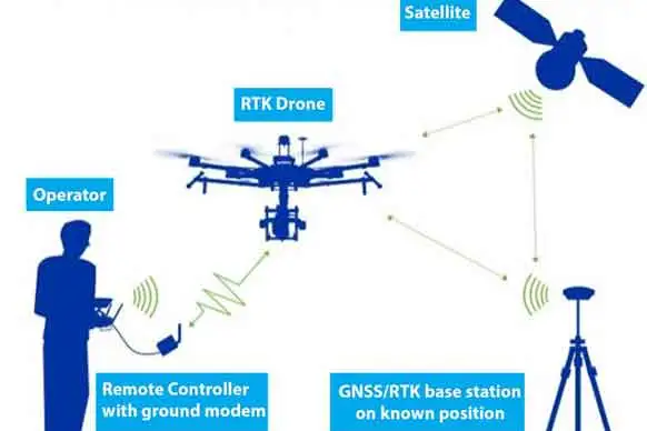
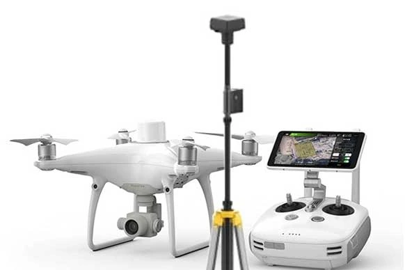
Training will take you through advance aerial surveying concepts with Drone, aerial surveying, GNSS/GPS, Photogrammetry fundamental concepts with hand on exercise on, flight planning, simulation, data downloading, exploring output like DEM, DTM, Point Could, Point could editing, removing noise, ortho-photo editing and much more. This Drone Surveying course also covers very important concept and end to end workflow of RTK/PPK drone surveying. Complete field and office procedure explained with practical. You will processing PPK data and apply correction and use corrected / Fix PPK solution data in image processing with photogrammetric software.
RTK Drone Surveying course design for experienced surveyors who know surveying instruments like Total Station, DGPS. Course covers various surveying workflows and drone data processing with most popular software tools.
2 days
Orientation on
Drone Surveying
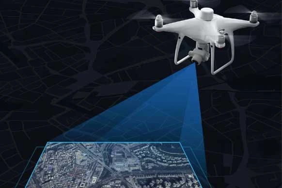
In India Drone are taking over on the traditional surveying methods. Drone Surveying save time and cost of project. Drones are being employ on many application like: Volume or earth work calculation in mining, change detections with LiDAR, Topographic Surveying of Roads, Dams, Bridges, 3D Modelling of archaeological, heritage site / monuments, power grid surveying, mining, forest surveying and change detection, Fishery surveys, Thermals Surveys of Solar panels, to generate high accuracy cadastral maps and many more. This training course will demonstrate you complete life cycle of drone land surveying project. Course includes fundamental concepts and flight planning, simulation, data downloading, data processing. No flying exercise for individuals included.
Orientation on Drone Surveying course designed for fresher and working professionals who are excited to know how drone surveying works.
Upcoming Batches
07-Jul-26 WeekDays
Kalyan, Mumbai
19-Jun-26 WeekDays
Dadar, Mumbai
04-Aug-26 WeekDays
Dadar, Mumbai
04-Aug-26 WeekDays
Dadar, Mumbai
Past participants work at:


Participant Profile
What Participant said:
Why Khagolam
Specialize Institute for Geoinformatics
Get benefited from Specialize and Dedicated Institute for Geospatial Technologies.
Industry Experts Guidance
Learn from expert and industry professionals with solid practical skills.
100% Placement Assistance
Job assistance with Resume Writing, Interview Preparation, MOOC Interview.
E-Library of Geospatial books
Read & Refer e-book on GIS, GPS/GNSS, Remote Sensing, LiDAR, Spatial Analysis.
Job Oriented Curriculum
Comprehensive curriculum covers geospatial industry practices, skills and project assignments.
Real Project Assignments
Industry project assignments help you to grab job ahead of the competition.
Flexible Timings
Learn at your own convenient time. Week-days, Week-ends, Online/Offline courses.
ISO Certified 9001:2015
Standard training procedure to assure quality and consistence training outcome.